Published: August 21,2017
 GOES16
infrared satellite loop of Hurricane Kenneth undergoing rapid
intensification from August 20, 2017 at 2:15 a.m. to August 21 at 2:15
a.m. PDT. The more vigorous convection is shown by the darker, higher
cloud tops.
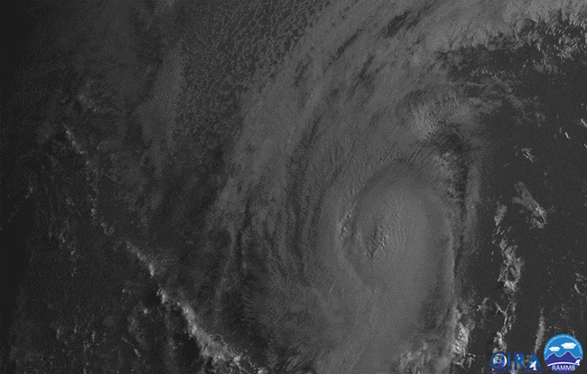
GOES16
infrared satellite loop of Hurricane Kenneth undergoing rapid
intensification from August 20, 2017 at 2:15 a.m. to August 21 at 2:15
a.m. PDT. The more vigorous convection is shown by the darker, higher
cloud tops. (MORE: Hurricane Central)
NOAA's new GOES-16 satellite captured the rapid intensification of Kenneth from a tropical storm just after midnight on August 20 to a Category 4 hurricane just 24 hours later well west of Mexico's Baja peninsula.
Kenneth estimated maximum sustained winds increased by 60 mph in that 24-hour timeframe. The pressure was estimated to drop 44 millibars from 2 a.m. PDT August 20 to 2 a.m. PDT August 21, according to the National Hurricane Center.
 Hurricane
Kenneth track history, with advisory estimated winds, central pressure
at 2 a.m. and 2 p.m. PDT August 20, 2017, then 2 a.m. PDT August 21.
Hurricane
Kenneth track history, with advisory estimated winds, central pressure
at 2 a.m. and 2 p.m. PDT August 20, 2017, then 2 a.m. PDT August 21. (INTERACTIVE: Kenneth Forecast)
Major hurricanes are Category 3-5 on the Saffir-Simpson Hurricane Wind Scale, and in general, make for some of the most spectacular satellite imagery given their extreme intensity.
Visible GOES-16 imagery caught much of the initial phase of rapid intensification on August 20, with a distinct eye becoming apparent by afternoon.
 GOES-16
visible satellite loop of Hurricane Kenneth undergoing rapid
intensification on August 20, 2017 from 8:15 a.m. to 7:15 p.m. PDT.
GOES-16
visible satellite loop of Hurricane Kenneth undergoing rapid
intensification on August 20, 2017 from 8:15 a.m. to 7:15 p.m. PDT. GOES-16 has been in testing mode since the beginning of the year and has seen a number of storms rapidly intensify over the eastern Pacific Ocean.
In mid-July, Fernanda went from a tropical storm to Category 4 hurricane in 30 hours from July 13 to 14. The previous week, Eugene went from a tropical storm to Category 3 hurricane in 24 hours from July 8 to 9.
Rapid intensification is defined as a tropical cyclone that increases its maximum sustained winds by at least 35 mph in 24 hours or less.
Rapid changes in intensity and smaller features that lead to changes in intensity are difficult to forecast because weather models have a hard time diagnosing those small-scale features in a hurricane's core that often lead to hurricane intensification.
(MORE: Top 10 Most Extreme Hurricane Seasons in the Satellite Era)
Models have improved in the last decade, but the addition of GOES-16 will help provide forecasters with more data in near-real time to better determine intensity changes in hurricanes.
In late July, Noru rapidly intensified to a Category 5 super typhoon over the western Pacific Ocean, roughly the magnitude of rapid intensification Hurricane Matthew underwent in October 2016 - 85 millibars in 24 hours.
None of these tropical cyclones comes close to matching Hurricane Patricia's rapid intensification in the eastern Pacific in October 2015. Its winds spiked 120 mph in 24 hours (85 mph to 205 mph).
The Weather Company’s primary journalistic mission is to report
on breaking weather news, the environment and the importance of science
to our lives. This story does not necessarily represent the position of
our parent company, IBM.
No comments:
Post a Comment