Published: October 26,2016
A parade of Pacific storms will march on through the weekend, bringing additional drought relief to parts of California and adding on to one of the wettest Octobers on record in the Northwest.
After one system clips the Northwest on Wednesday, another wetter storm will slide into California with heavier rainfall to end the workweek. That system may tap some mid and high level moisture from Seymour, which will stay well to the south in the eastern Pacific Ocean.
Current Satellite
Wet Forecast For Last Full Week of October
Below is a rough timeline for the next series of Pacific systems and where they are expected to spread rain and mountain snow.Current Radar
- Thursday/early Friday: California (including L.A.) wettest, Oregon, Washington, Great Basin (Some Sierra snow, California thunderstorms also).
- Saturday/Sunday: Northern California, also Oregon and Washington (rain, mountain snow, some t-storms also possible). Some moisture spreads to Nevada, northern Utah, and Idaho.
Five Day Forecast
A couple of inches of rain is possible along the I-80 corridor, including parts of the Bay Area and Sacramento.
Rainfall totals farther south remain somewhat uncertain. The best chance for an inch of total rain will be near Point Conception and Santa Barbara County.
If moderate to heavy rain does develop in Southern California, there will be the risk of mudslides and debris flows on recent burn areas. The likelihood of heavy rain in Southern California is unlikely.
(FORECAST: Los Angeles | Portland, Oregon | Seattle)
Rainfall and Snowfall Forecast
Recap of Pacific Storms So Far This Week
On Monday, the first Pacific storm along with a separate upper-air disturbance soaked parts of Northern California and the Northwest, and brought a flare-up of thunderstorms to Southern California and the Desert Southwest.Drought Improvement
A series of low pressure systems brought much-needed rainfall to the Pacific Northwest earlier this month. Damaging winds were also observed in Oregon and Washington the weekend of Oct. 15.The drought monitor released on Oct. 20 showed, for the first time since early June, a small part of California that isn't analyzed as even abnormally dry, in the far northwest corner of the state. In fact, 7.77 percent of the state is not experiencing at least abnormally dry conditions, which is the most since March 2013.
 Drought conditions across the West as of October 18, 2016 (data from droughtmonitor.unl.edu).
However, the area that needs to see rain and snow the most remains central and southern California. Portions of Southern California, including Los Angeles, did receive some rainfall in recent days.
(MORE: Los Angeles Rain Causes Traffic Problems)
Hopefully this pattern of low pressure systems moving into the West Coast will persist as we head through fall and into this winter. Snowfall, in particular, is important in the Sierra as far as the water supply for California. However, rain is also needed and is helpful in at least moistening the soil to help prevent wildfires at this time of year.
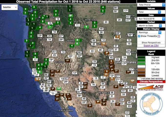
A Wet October in the Northwest
There also was huge improvement in Oregon and Washington as well.The drought monitor report for Oct. 11 showed 84.46 percent of Washington seeing at least abnormally dry conditions and, as of Oct. 18, only 7.91 percent was still experiencing dry conditions.
(MORE: Is Seattle's Rainy Reputation Deserved?)
Seattle has already received over 7.5 inches of rainfall in October. On average, Seattle sees about 5 days per year with an inch or more of rainfall and, from Oct. 13 through Oct. 20, they had seen 3 days with at least an inch of rain.
Wettest Oct-to-date (through Sunday) in Portland, OR...Salem, OR...Eureka, CA. And more is on the way. http://wxch.nl/2ekD53w (Map: @SERCC)
MORE: California Fires, September 2016 (PHOTOS)


No comments:
Post a Comment