Published: October 30,2015
The flash flood emergency was in effect for much of Comal County, as well as parts of Hays and Bexar counties, according to the National Weather Service. This includes areas like northern San Antonio and New Braunfels.
(MORE: Track Severe Weather in the South)
A separate flood emergency was issued in South Austin, in areas near Onion Creek in Travis County. For those looking for a place to take shelter in the Onion Creek area, Dittmar Recreation Center has been made available.
Near Driftwood, Onion Creek quickly rose to a new record level. Before noon Friday, water levels at that part of the creek were already above the previous record of 25.1 feet, and the waterway was expected to continue its rise.
"We do have some water rescues ongoing, and that could become a bigger problem later today if the rain continues into rush hour," said Joe Arellano, meteorologist at the National Weather Service in Austin, while speaking with The Weather Channel.
The rainfall became so extreme that the airfield of Austin-Bergstrom International Airport had to be closed late Friday morning, the airport announced.
Floods Force Evacuations
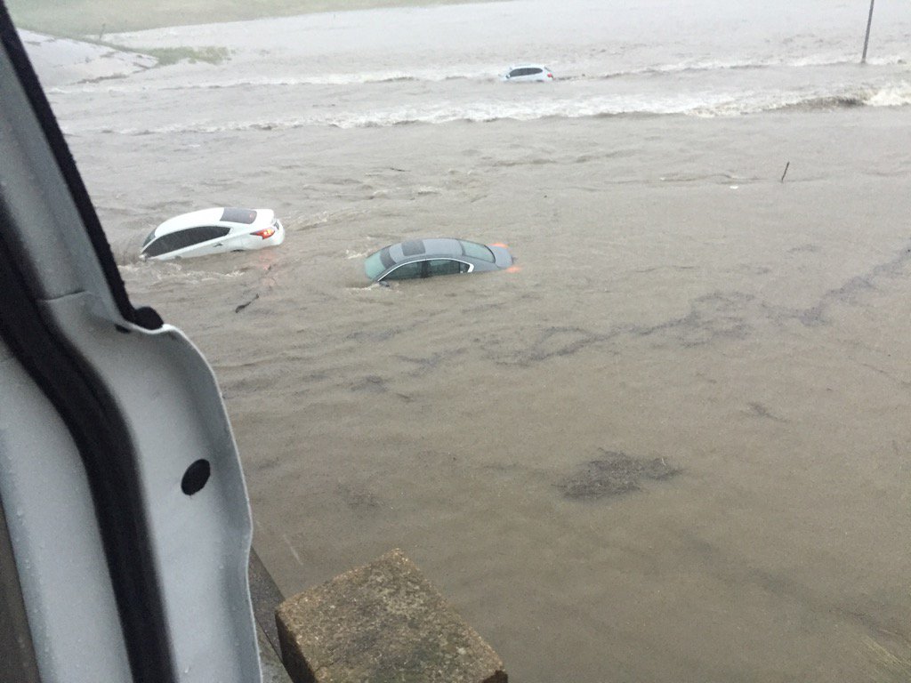
Evacuations were ongoing in the Wimberley area Friday morning, as a bridge over Cypress Creek may be threatened by rising floodwaters. Rain was falling at rates of up to 6 inches per hour Friday morning in Texas, storm reports showed.In Austin, boats were being deployed by the Austin Fire Department to help with water rescues. Passenger vehicles were nearly submerged by floodwaters near the interchange linking U.S. Highway 183 and State Route 71 near Austin Bergstrom International Airport late Friday morning.
U.S. 183 from overpass on 71
San Antonio officials reported more than a dozen road closures Friday morning as heavy rain caused flooding. In eastern Bexar County, a school bus with children inside got stuck in high water, and crews were able to successfully remove everyone inside, the Bexar County Sheriff's Office said via Twitter.
New Braunfels officials warned residents to take flooding seriously and get to safety. A civil emergency message was issued for Comal County, warning residents that river flooding along the Comal and Guadalupe rivers was imminent, and residents in low-lying areas should evacuate to Canyon High School.
Texas State University announced its Round Rock and San Marcos campuses would be closed on Friday as a result of the conditions.
Reported Tornadoes Leave Damage
The towns of D'Hanis and Floresville took the hardest hit from the early Friday suspected tornadoes. There were also reports of damage near San Marcos as the severe weather pushed northeast.NWS meteorologist Jason Runyen said businesses have been damaged in downtown D'Hanis and that trees are also down. Medina County authorities told NBC San Antonio that a bank was destroyed and other buildings were damaged, but they were unsure if there were any injuries.
The Wilson County Sheriff's Office told The Weather Channel that Floresville High School was damaged. No injuries have been reported from either of the suspected tornadoes.
Floresville ISD said on its Facebook page that schools will be closed Friday.
Storm damage along HWY 97 in #Floresville, TX southeast of #SanAntonio. Pic courtesy of @Alexis_2016. #TXwx
Floresville HS after the tornado this morning. Not far from my house.
Downtown D'Hanis!
D'Hanis is located some 50 miles west of San Antonio, while Floresville is about 30 miles southeast of the San Antonio. The two cities are about 70 miles apart.
More Storms on the Way
Severe weather is expected to continue in the Southern Plains throughout the day. Over the weekend, other areas could also see dangerous storms."The threats are two-fold. First, warm and very humid air coupled with an approaching southward dip in the jet stream will spawn severe thunderstorms, some of which may spawn tornadoes, in Texas and the Deep South through Saturday," said weather.com meteorologist Jon Erdman. "Secondly, areas of slow-moving, heavy rain will trigger flash flooding in Texas and Oklahoma through early Saturday, then spread into the Lower Mississippi Valley and Deep South later Saturday. This flood threat includes San Antonio, Austin, Dallas and Houston."
This is a developing story. Please check back frequently for updates.


Awesome Post Storm damage in Texas
ReplyDelete